


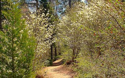
From the trail’s halfway viewpoint, Lake Arrowhead appears with a backdrop of mountains even farther east. (Photos by T. Wilcox)
By TIM WILCOX
Special to the Alpine Mountaineer
Where: Lake Arrowhead
Length: 2.5-mile loop
Elevation gain: 483 feet
Challenge: moderate to semi-difficult
Situated on Grass Valley Road across from the Lake Arrowhead Country Club is an 80-acre site that failed commercially, then became a success environmentally.
Arrowhead Ridge was once a high-end residential development. Some infrastructure, including the main roadway, was completed before construction ground to a costly halt. The prime parcel languished until 2011, when the San Bernardino Mountains Land Trust purchased it from the developer and began painstaking restoration of the site.
More than a decade later, this multifaceted project continues—marked in particular by encouraging regrowth of what once was a pristine forest.
The trail was named to honor Will Abell, a longtime, highly regarded Land Trust volunteer who died in 2012. A lifetime mountain resident and artist, he was a prime mover in scouting a trail route and actually building its first segment.
OK, parking is almost never a problem here. Most of the spots are steps away from the on-site Lake Arrowhead Veterans Memorial. The actual lower trailhead, though, is a hundred yards or so south of that area where two boulders block vehicle access to a long-unused side street. A new sign has been erected immediately to the left of those boulders.
By the way, there are two more trailheads at the top of the steep main roadway, which remains an unfortunate blight on the site. I’d suggest that you prefer the principal access point in the parking area.
On the Trail
Narrow at the start and most of the way, the trail heads uphill, with switchbacks moderating the ascent. The surrounding forest favors mature pine and fir trees. There are quite a few young oaks as well.
About one-third of a mile into your hike, you’ll encounter a T-intersection with new signage pointing to the right. The route has been shady most of the way, which is welcome during these closing summer weeks. That level of robust foliage also attests to the fundamental good health of this southern Sierran native forest.
Now the trail ascends more steeply and continues to rise for some time. A level stretch is followed by a gentle descent past a large Ponderosa and sequoia, then through a light-green mini-forest of young firs.

The trail bisects the remnants of an enormous redwood, fallen decades ago with a base diameter of nearly eight feet. Living giant sequoias of similar or even greater size are thriving in the magnificent Ann Henck Stewart Memorial Grove at Heaps Peak Arboretum
Soon you encounter a wizened oak that must be centuries old. It just has that look. A few paces beyond that, you come upon the remnants of a huge sequoia that, at its base, must have displayed a diameter approaching eight feet. The trail passes through a sliced-out section of the fallen giant.
It rises now for a long stretch with several switchbacks. This could be the trail’s most challenging portion due to the prolonged ascent. On the left you’ll encounter a smooth-topped stump that invites a quick break. Have a seat and relax!
Exactly one mile into the hike, you’ll come to a pair of signs. The top one indicates that the main trail is straight ahead, while the bottom sign directs you to a viewpoint. Head to the right for a couple hundred yards, and you arrive at the vista.
There’s Lake Arrowhead to the east—the view framed by thick foliage. Is it a spectacular vista? No. Still, it’s quite striking.
Back on the main trail, you start heading down after climbing most of the way. Another sign directs you to the left, where the trail becomes steeper and meanders through a series of switchbacks for a least a quarter of a mile.
Finally, you come into a clearing and sense that the trail is nearing its terminus. Your sense is correct. One hundred yards or so later, you step off the beaten-earth pathway and onto the main Arrowhead Ridge road. Head downhill for a few minutes, and you’re back in the parking area.
This is one of the western San Bernardinos’ most neatly laid-out and well-maintained trails. Bigtime BRAVO to the San Bernardino Mountains Land Trust!
NOTES: Thanks to the flag-festooned Lake Arrowhead Veterans Memorial on site here, it’s easy to locate this trail setting (across Grass Valley Road from the country club’s far-south section). An exemplar of excellent “public interest” land and forest management, the trail itself is 2.2 miles long. Add the downhill segment on the abandoned main road, and your hike is 2.5 miles.


0 Comments