



By TIM WILCOX
Special to the Alpine Mountaineer
Where: Lake Arrowhead
Length: 4-mile round trip
Elevation gain: 272 feet
Challenge: easy to moderate
As fall gives way to winter (the solstice is Dec. 21), more and more of our area’s trails become inaccessible or, at least, increasingly difficult to traverse. That’s due to predicted/expected levels of snow and ice, of course.
More ambitious hikers (with traction cleats attached to their boots) and snowshoe devotees remain undaunted. But caution and convenience can motivate one to look for more manageable options.
One obvious choice is to hike along neighborhood streets that have been cleared, keeping a watchful eye out for traffic. Then there’s a whole network of Forest Service routes and unofficial dirt roads spider-webbing across the San Bernardino Mountains.
A prime example is Rouse Ranch Road. It begins as the left branch from Torrey Road (right turn off Highway 173 across from the Arrowhead Lake Association boat-launching ramp). The initial uphill section of Rouse Ranch Road is paved. Then, at the top of the hill and, just days ago, past the construction site, it becomes a dirt road.
You’ll need to go left there, however, and leave your vehicle in MacKay Park’s large lot. Then walk back along that paved stretch for three-tenths of a mile, turning left at the Lake Arrowhead Community Services District’s new corporate yard onto what soon becomes a dirt road. Rouse Ranch actually extends for quite a few miles, winding in a northeasterly direction into the wilderness until it intersects with Squint Ranch Road. We’ll simply venture two miles in, resulting in a four-mile hike.
On the Road
Soon you’ll pass through an open gate and cross the North Shore Trail that meanders down from the campground above. As you proceed, you’ll notice that the road is heavily rutted in spots with a lot of loose stones. Caution is advised.
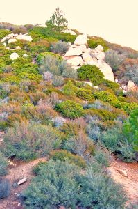
As you approach the end of this week’s hike, the terrain becomes increasingly rocky with vegetation typical of the mountains’ chaparral biome.
This is a wide-open hike, with just a few trees on either side. The western chaparral biome – Manzanita and other hardy shrubs – predominates.
The farther you proceed, the more removed you are from traffic noise. It’s an increasingly peaceful hike. And while it is a road, you’re hiking in the wilderness. This means that mountain lions are probably permanent residents here, though you’re unlikely to meet any of the big cats. Still, as we’ve noted before, it’s smart to carry a canister of bear spray or mace when you’re hiking in remote areas.
The route is mostly downhill, with a few level and slightly rising stretches. There’s a chance you’ll encounter an off-road four-wheeler or a dirt bike (especially during warmer months) but, unless you’re listening to music with headphones or earbuds, you’ll hear them coming. Just be aware of that possibility, please.
The lowest point of the hike occurs at about the 1.5-mile mark. Then the road suddenly becomes a markedly uphill route. Along this stretch there are some slippery spots caused by loose sand. Again, walk with care. Views of a mini-valley to the right and more distant mountains in several directions are delightful.
The hillsides here are clearly more heavily strewn with boulders, which could signal a transitional zone of some sort. If you have a geologist hiking with you, he or she can address that possibility.
Finally, as the road levels out, you’ll see a big post on the left supporting a barbed-wire fence. Immediately beyond it is another road. A few more steps and you’ll have reached the two-mile point. How can you tell? It’s a confluence of several off-road routes clearly marked by Forest Service signs.
Pause here for a moment to savor the views. Almost directly north are Hesperia, Victorville and Apple Valley in the High Desert. To the northwest, The Pinnacles are clearly visible. Now it’s time to retrace your steps, returning to MacKay Park after an enjoyable, aerobically beneficial foray. How long does it take? About 90 minutes.
NOTES: Rouse Ranch Road offers an away-from-traffic, easy-to-moderate hike through chaparral-covered hills. During summer months it can be too warm, similar to The Pinnacles Trail. But this time of year, it’s quite pleasant. When the road’s covered with snow, make sure to have boots with traction cleats. Icy spots are inevitable.





0 Comments