




By TIM WILCOX
Special to the Alpine Mountaineer
Where: North of Lake Arrowhead
Length: 4-mile round trip
Elevation gain: 144 feet
Challenge: easy to moderate
The rocky and relatively remote area north of Lake Arrowhead is one of our mountains’ preeminent hiking destinations. We’ve already visited The Pinnacles, Metate and Deep Creek trails. This time let’s venture onto the Pilot Rock Trail.
Again, you’ll be motoring along Highway 173 past Mountains Community Hospital and North Bay Road through an exceptionally winding stretch. About five miles from the hospital turnoff (immediately beyond the massive Caltrans retaining wall), you’ll come to the Metate Trailhead parking area – an open expanse of dirt and gravel. Secure your vehicle and walk a few steps south to Pilot Rock Road. There’s no street sign there, but it’s the only paved route branching to the west off of Highway 173. It’s also the starting point for this latest “Let’s Go Hiking” adventure.
On the Road and Trail
As you’re ambling along the road, The Pinnacles’ monumental presence looms on the right. While this view is no surprise, it’s always inspiring. Nearly four-tenths of a mile from your starting point, though, you’ll encounter something really unexpected (unless you’re already familiar with the area). Looking almost like a country club at first glance, with neatly manicured lawns and debris-free driveways, it’s a Lake Arrowhead Community Services District (LACSD) facility.
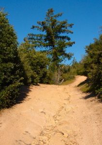
The dirt road/trail shows signs of significant water erosion in many spots, especially on its steeper stretches.
Its official name, according to Catherine Cerri, LACSD’s general manager, is the Grass Valley Wastewater Treatment Plant. She reports that it encompasses 7.5 acres. She also notes that LACSD’s staff members “take great pride in maintaining our facilities.” That’s oh, so apparent!
Anyway, we’re hiking and not admiring municipal installations – however well-kept they might be. A few steps farther, the pavement ends. Then, on the right, you’ll see a sturdy steel portal to a dirt road. This is an entryway not only for hikers, but also for off-road vehicles. It limits their width to 50 inches, which is a good thing. Still, most hikers would prefer that no dirt bikes or four-wheel vehicles be allowed at all. At least you’ll know to look and listen for them, especially on weekends.
Full disclosure. . . This is not the principal Pilot Rock Trail. That route meanders downhill past the steel portal on a wider dirt road that’s also frequented by recreational vehicles. It’s our destination for next week’s column. Consider this to be a “prelude hike” – an introduction to the Pilot Rock neighborhood.
Hike to the right, then, on what’s both a road and a trail. You’ll immediately encounter a steep climb to a nearby hilltop. The deeply rutted path is covered with loose stones and gravel, so proceed with care. After your ascent, the trail levels off for a ways, then passes two branches on the right. We’ll come back to one of them, but for the moment continue straight ahead past a high-tension-power-line tower. Ignore that intrusive element. Instead, savor the splendid views of The Pinnacles on your right. Notice the deep valley ahead as well, which leads all the way to Silverwood Lake more than 10 miles to the west. Magnificent!
Thick stands of chaparral and a few oaks cover the hillsides along the trail. Pines and firs are in the distinct minority. Far from any traffic, you’ll be struck by how quiet it is along the route. Only an occasional jet, passing far overhead, disturbs the serenity.
A second high-tension tower appears at the 1.5-mile mark and, somewhat abruptly, the trail ends. Head back now until you come to the two offshoots mentioned earlier. Unless you have deadlines and commitments, hike up the ascending branch to enjoy more views of The Pinnacles. Then head carefully down the steep, rutted path, which levels off by the wastewater-treatment facility. Follow the route uphill for another 10 minutes or so, then turn around.
When you come to the original trail, bear left. Taking care once again, navigate the steep and rocky downhill stretch to the steel portal. Turn left there and head back along Pilot Rock Road to your vehicle. Some 90 minutes since your foray began, you’ll have covered approximately four miles.
NOTES: This “prelude hike” is an introduction to the Pilot Rock neighborhood. Tracing a route that’s also open to off-road vehicles (sanctioned by the U.S. Forest Service), you’ll discover that it tends to be quieter and safer on weekdays. Temperatures here soar into the 80s and low 90s during peak summer weeks.





0 Comments