



By TIM WILCOX
Special to the Alpine Mountaineer
Where: Lake Arrowhead
Length: 5.2 miles
Elevation gain: 483 feet
Challenge: moderate to semi-difficult
One of the most hikable and likable routes in our area has been expanded. Thanks to the visionary management of the San Bernardino Mountains Land Trust (SBMLT), the Will Abell Memorial Trail at Arrowhead Ridge is now more than twice as long as its previous incarnation. The site itself is larger, too. SBMLT bought an additional 94 acres, boosting the acreage to 172. This project was made possible by strong support from the San Manuel Band of Mission Indians, Land Trust volunteer Scott Seccombe’s “Go Fund Me Barefoot Hike” and generous contributions from Land Trust volunteers, members and donors.
According to SBMLT, “The project now includes trails, signage, kiosks posted with maps, and educational information about indigenous stewardship, endangered species and the protection of Arrowhead Ridge.”
This was once planned to be a high-end residential development. Some infrastructure, including the central roadway, was completed before construction ground to a costly halt. The parcel languished until 2011, when SBMLT purchased it from the developer and began painstaking restoration of the site.
The principal trail was named to honor Will Abell, a longtime, highly regarded Land Trust volunteer who died in 2012. A lifetime mountain resident and artist, he was a prime mover in scouting the trail’s initial route and actually building its first segment.
You’re probably already aware that Arrowhead Ridge is on Grass Valley Road across from the southern end of Lake Arrowhead Country Club (just north of Agua Fria). The flag-festooned Lake Arrowhead Veterans Monument on site makes it easy to spot. Parking is somewhat haphazard in the large entryway lot but almost always available. Once you’ve secured your vehicle, you’ll find the main trailhead just beyond the wide street leading up to the ridge itself. Obviously intended for motorized traffic, that ill-fated pavement has been a hikers-only passageway since SBMLT took possession of the failed development.
On the Trail
Narrow at the start, the trail winds upwards with quite a few twists and turns. Then it levels off and heads downhill into a more thickly forested section before proceeding uphill once again. At the 0.2-mile mark, the path widens noticeably, then returns to its narrow format. Steps later you’ll come to a T-intersection, with the trail heading right. (If you were to turn left instead, you’d soon come to one of the two upper trailheads.)
Now the route passes through a forest dominated by evergreen trees, with oaks playing a minor arboreal role. On the right you’ll see a pair of especially prominent Ponderosa pines, one of them towering more than 120 feet.
Shortly thereafter, the trail transitions from moderately uphill to downright steep. Then, at about the half-mile mark, you’ll hike through a mini-forest of baby and adolescent firs growing closely together. Most of them won’t survive as competition increases over the years for growing space at ground level and canopy expanse high above.
Ahead is a fallen giant sequoia, which has been lying on the ground for decades. When alive and at its pre-tumble peak, this monarch must have boasted a base diameter approaching 10 feet. The trail passes through a chain-sawed opening in the tree’s midsection.
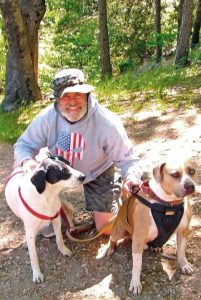
Hugh James Rochford, an Orange County resident who lives in Tustin, has had a getaway home in Agua Fria for 27 years. A finish carpenter and contractor poised to retire, Hugh has visited this forest and its trails too many times to count. He’s an Air Force veteran who’s rescued a number of dogs. Pictured here are two of them: Sammy (right) and Peewee.
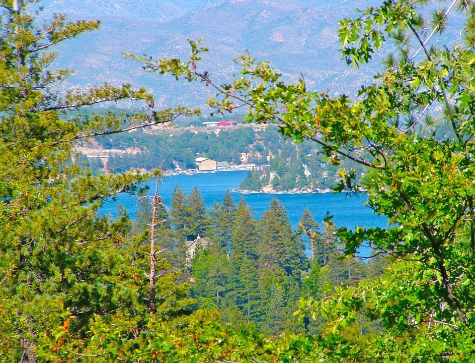
It rises now for a long stretch with several switchbacks. Exactly one mile into the hike, you’ll come to a new kiosk with a large graphic depicting Arrowhead Ridge and the expanded trail. On the kiosk’s flipside is interpretive text. To the right, a small wooden sign directs hikers to a viewpoint. Head in that direction 100 yards or so, and you’ll arrive at the lookout. There’s Lake Arrowhead to the east – the view framed by oak and fir foliage. Pause for a few moments to savor the buena vista.
OK, return to the kiosk and head down along the main trail, which at this point is almost as wide as a small road. When you come to more signage, continue to the right, following a route that narrows slightly. Here, too, as has been the case from the start, the forest shows encouraging signs of robust good health.
Another kiosk, identical to the previous one, is located at a T-intersection. The main trail winds to the left. To the right is what appears to be the Little Bear Loop, though there’s no identifying signage. While this isn’t a freshly created path, it is a new extension of the overall trail. That said, it’s worth exploring.
You’ll pass through a leafy tunnel created by overarching shrubs, heading mostly downhill. Instead of continuing to descend at a fork, go to the left. Do the same at the next fork, which reveals what appear to be “ancillary paths.” The leftward route narrows considerably, approaching a foot and almost disappearing in a thicket of young firs.
Finally, you’ll arrive at an open area that seems out of tune with the lovely forest setting. Why? Because this scar is what the ill-fated developers envisioned as a side street. Fortunately, it’s increasingly covered by ground vegetation and bordered with trees and shrubs.
Amble downhill until you come to a cul-de-sac. Turn left there, then left again onto what would’ve been a successful residential development’s main street. Two-tenths of a mile later, you’re back where you parked. You’ll have covered about three miles.
NOTES: More signage is needed to clearly identify the Little Bear Loop branching from the main trail and also the Old Toll Road connector off the loop. The Land Trust is likely planning such navigation enhancements. Now officially part of the Will Abell Memorial Trail, Old Toll Road augments the hike to about 5.2 miles. The opening celebration was staged on Saturday, May 18.





0 Comments