




By RHEA-FRANCES TETLEY
Historian
Driving along Highway 18, many have missed or wondered about the wooden oxen yoke sitting on a rock base at the unusual intersection with Daley Canyon. The Daley Road Monument is located between Rimforest and Rim of the World High School, at the curve where Daley Canyon Road appears to begin its way to Agua Fria and Blue Jay. In reality, historically the monument marks the location where the original road finally crossed the crest on its way from Del Rosa to Little Bear Valley.
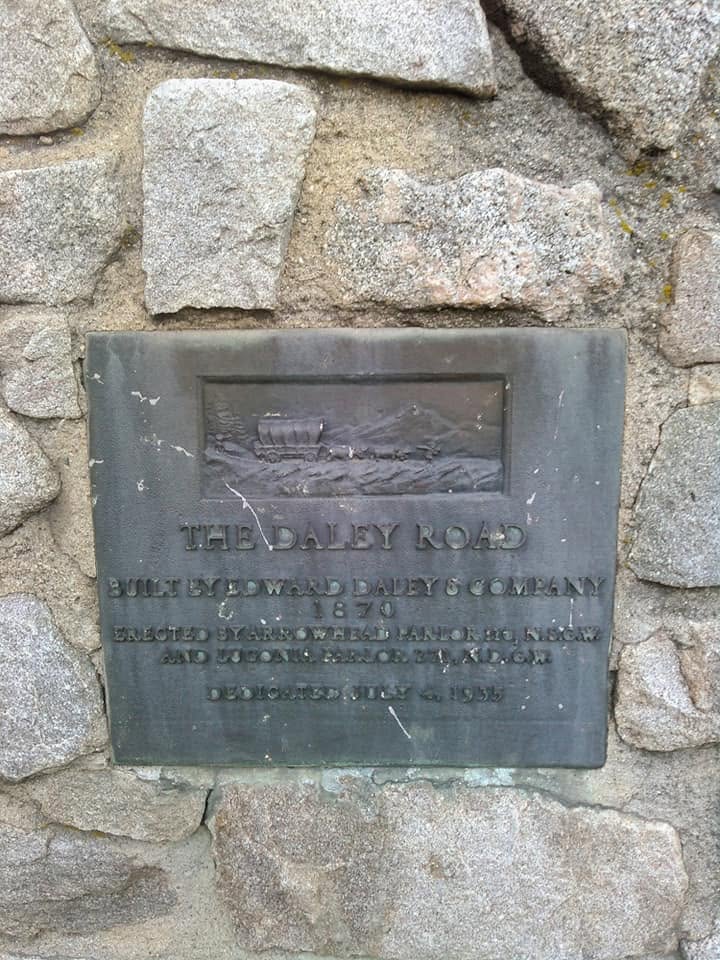
A close up of the plaque on the monument.
It is a monument to the dirt roads of the 1870s, many of which were constructed by the Daley family, honoring the dangerous route the lumber wagons traveled as they left the mountain, before our mountain lakes were built.
The oxen yoke monument was placed there on July 4, 1935, just after the Rim of the World High Gear Road was completed. It was installed by the Arrowhead #110 and Lugonia #271 parlors of the Native Sons and Daughters of the Golden West. Decades later, John Dexter rehabilitated this monument, just in time for it to be designated as California State Historical Monument #570 in 1957.
Since logging was such a profitable business from the 1870 to 1880s, Edward Daley with his family and investors, the Twin and City Creek Turnpike Company, began surveying to construct a logging road into the mountains to reach the mid-mountain area of Little Bear Valley. They chose the canyon north of Del Rosa, where the Daley Farm was located, going up the steep slopes between Strawberry Creek and the west fork of City Creek, cresting the mountain just east of Strawberry Peak (where the monument is located), then descending to Little Bear Valley (L.B.V.) through Daley Canyon, alongside the headwaters of the future Lake Arrowhead. The Daley Road offered convenience to the Talmadge, LaPraix and other L.B.V. sawmills, enabling them to expedite the transportation of lumber down the mountain.
The original road was narrow, only 12 feet wide and steep with 10 to 15-percent grades; although difficult for today’s cars, that was somewhat a normal grade for horse-drawn wagons. It was built by Edward Daley and Company (his sons), and was called the Mountain Turnpike or the Twin and City Creek Toll Road. This became the road that was used to transport lumber from the Little Bear Valley area, current-day Blue Jay and Lake Arrowhead, to the valley below.

The Daley Road (aka Twin and City Creek Toll Road), built up from Del Rosa, opened the Little Bear Valley (Lake Arrowhead) area to lumbering in the 1870s. This monument marks the location where the road crossed the crest.
The previous Mormon Lumber Road had been washed out by the Noahian Deluge in 1862 and was again flooded in 1867, making that road almost impassable and rarely used for almost a decade.
The first lumber to be moved over the Daley Road was in April/May of 1870. However, its grand opening was held on July 4th of that year, with a grand barbecue, speeches, a brass band and … an unexpected thunderstorm.
The next day, the toll rates signs went up at the upper and lower tollhouses. The one-way rate for wagons and two horses was 37-1/2 cents, while wagons with six horses were charged 62 cents (they could eat more grass along the way). Carriages were 50 cents (usually carrying tourists that lumbermen wanted to avoid), sheep 5 cents (they usually were brought in herds anyway), cattle or horses 50 cents and single horsemen and pack animals were 25 cents.
This was the chosen road used by the Caley, Talmadge, LaPraix and other Little Bear Valley mills as it was the most direct route to the valley. However, because it was a narrow, winding and steep road, it took a good driver about six to seven hours to make the one-way trip down the mountain with a load of lumber.
The upper tollhouse became known as Old John’s Saloon, run by John Commerford. Located in the trees just north of the monument, it sold tobacco, liquor and playing cards, and was renowned for the wrestling matches held there between the various teamsters as a diversion between loads and before the perilous trip down into the San Bernardino Valley.
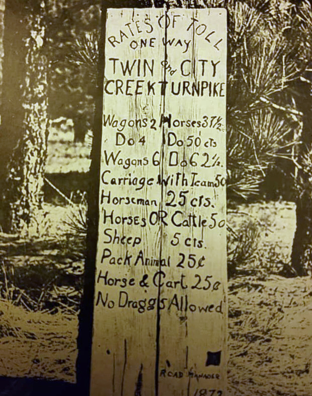
Sign of toll rates for Twin and City Creek Toll Road aka Daley Lumber Road.
Keeping the team under control while going down the steep downhill sections – and meeting face-to-face with an uphill wagon on the 12-foot-wide road – was dangerous for all. About 30 wagons a day used the new road. Despite the steep cliff along its edge and the hairpin curves, it was over a year before the first accident occurred on the road.
By the 1890s, most of the lumber mills in the Little Bear Valley were either bought or closed, because of the beginning of the construction of the dam to create Little Bear Lake and the establishment of the National Forest Preserve in 1891. Also, the wider, lesser grade Arrowhead Reservoir Toll Road ($2) opened through Waterman Canyon to bring the materials up the mountain to build Little Bear Lake, so the Daley Canon Road lost most of its appeal, although its tolls remained much lower.
Edward Barber Daley, who built the road, had married Mormon Battalion Captain Jefferson Hunt’s daughter, Nancy Ann, in 1846. They arrived in San Bernardino with the first Mormon immigration in 1851.When the Mormons were called to return to Salt Lake City in 1858, Daley stayed. He was elected Third District County Supervisor, serving from 1880 to 1883. During Governor Waterman’s tenure, Daley sold part of family’s large farm in Del Rosa to the state to become Patton State Hospital.

View down the mountain toward Del Rosa.



0 Comments