




By RHEA-FRANCES TETLEY
Historian
Baylis Park is located on the south side of Highway 18, about a half-mile east of the Lake Gregory Drive signal on Highway 18. This spot was a part of Pinecrest’s South Park, and the day-use picnic area was named to honor Dr. John Baylis who named the Rim of the World Drive in 1915 when the compacted dirt roadway was opened to auto traffic.
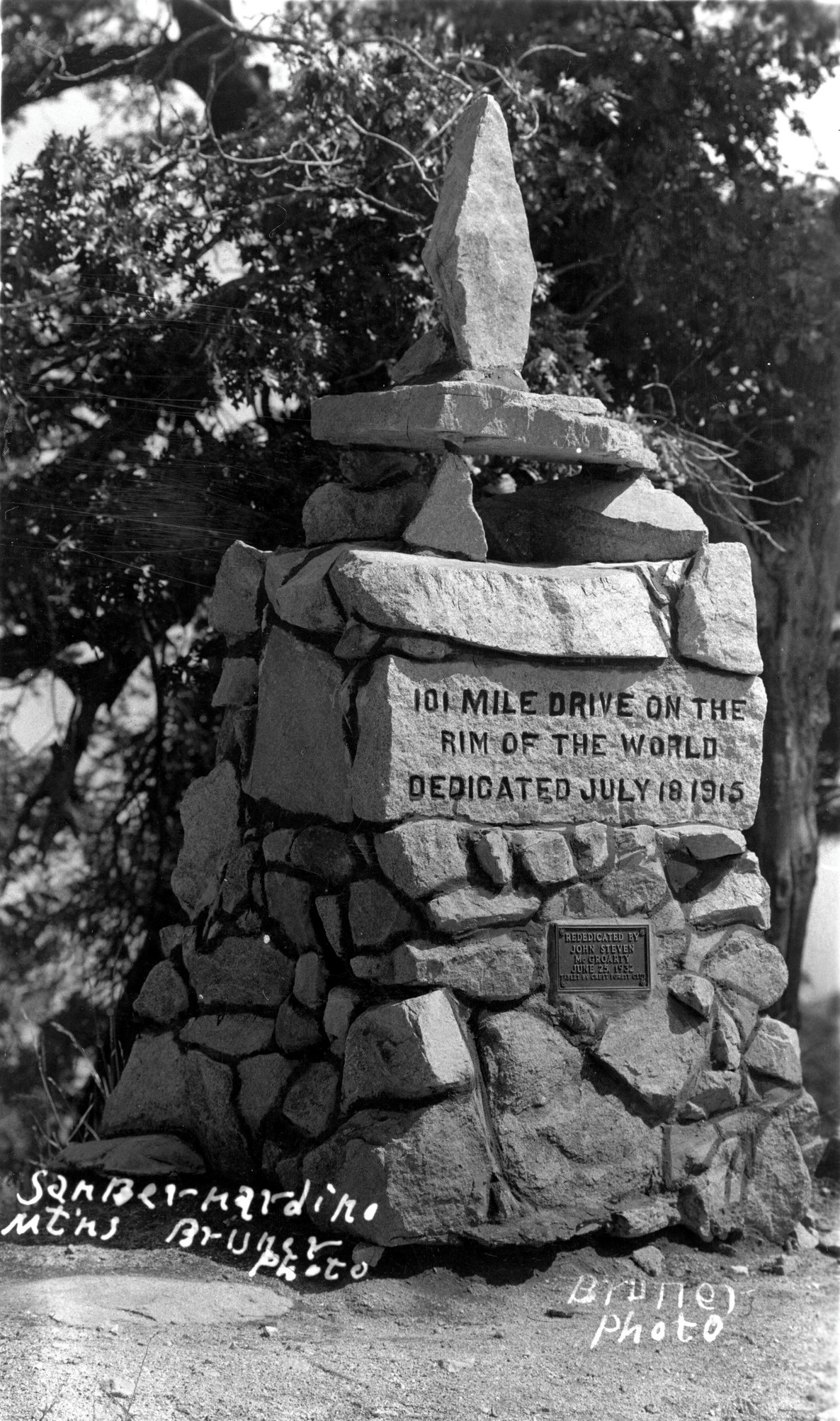
The original rock 101 Rim of the World Monument, dedicated by Dr. John. N. Baylis on July 18, 1915.
Moving to San Bernardino in 1887, Dr. John N. Baylis was a doctor for the Santa Fe Railroad. He loved the forest and the San Bernardino Mountains, serving as president of the exclusive Arrowhead Mountain Club at the Squirrel Inn for 10 years. The club catered to the rich, who were conservation-minded about the forest.
When Baylis was informed the Smithson Guest Ranch (the 160 acres adjacent to the Squirrel Inn) was to be sold to the Guernsey Lumber Company in 1904 to be lumbered, he went to Lewis Jacobs of the Bank of San Bernardino and secured a $4,500 loan to buy the property on his signature alone. He then borrowed another $4,000 to begin building the Pinecrest Resort, which he envisioned would open the mountains to visits by all residents of the San Bernardino Valley and beyond.
Baylis began by revamping the Smithsonian Lodge. He added cabins, a boarding house, an assembly hall and stables, using local lumber and rocks for construction. Access to the mountains at the time was by the horse-drawn carriages.
The Smithsonian portion of the Pinecrest Resort opened in 1906 and needed customers. The Pinecrest Resort fully opened in 1909. Baylis was one of those who had encouraged the county to purchase the lumber toll roads to open them to free public use. He began a publicity campaign advertising the San Bernardino Mountains, its beauty, its trees and the coolness of the clear air and sparkling water.
To create even more tourism, he helped motivate the creation of the Crest Road, a road loop which began in San Bernardino, went up Waterman Canyon and across the crest to Big Bear and back. “No such drive exists in all America as that 40 miles east from Skyland looking out over the San Bernardino Valley and out to the sea,” Baylis wrote. Baylis then encouraged the county supervisors to open the Crest Road to auto traffic.
When the Rim of the World Drive was opened to auto traffic in 1915, the dedication of the Rim of the World Drive Monument was held on Pinecrest’s South Park property. Baylis’ Pinecrest became the most popular public resort in the mountains and remained so for many years. By 1917, it could host 700 guests at the same time.
In the 1930s, when the realigned High Gear Road was cut into the south face of the mountain to replace the 1915 Rim of the World Drive, the Rim of the World Monument was relocated next to the new roadway, where it remained until 2008.
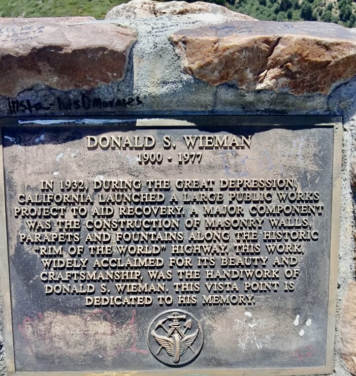
The Weiman plaque currently at Red Rock Wall turnout.
Baylis Park was created as a roadside picnic area along Highway 18 between Arrowhead Highlands and Rimforest in the 1930s by the Works Progress Administration (WPA). Named in Dr. Baylis’ honor, it is located where Pinecrest guests previously would ride out to the South Park cliffs and enjoy the spectacular view.
Baylis Park is the current location of the 101 Mile Rim of the World Monument that was restored and rededicated on July 18, 2009, by the Rim of the World Historical Society, which operates the Mountain History Museum, located at 27176 Peninsula Drive at Rhine Road in Lake Arrowhead. They have on display the brass plaque that honored Dr. Baylis and his massive oak tree memorial.
Baylis Park is a natural botanical garden, featuring San Bernardino Mountains native plants and trees along its trails.
Red Rock Wall scenic turnout
Just a half-mile east of Baylis Park is the Red Rock Wall scenic turnout. The red rocks, mined from the south slope of Big Bear, appear very distinctive compared to local granite rocks.
This portion of Highway 18 is recognized for its beauty and amazing panoramic views of the valley, including west to the tall buildings of downtown Los Angeles, Saddleback Mountain and Moreno and Perris Valleys, plus the Pacific Ocean to the south and Mt. San Bernardino, Mt. San Gorgonio and Mt. San Jacinto to the east. The sunsets from Red Rock Wall are spectacular most months of the year and photographers are often seen at sunset capturing those colorful views, with the sun reflecting off the ocean water far to the west.
After the construction of the paved High Gear Road in 1933, the Red Rock turnout was completed by the WPA. California Highway Engineer E. Q. Sullivan was honored with a bronze plaque placed on the large red rock domed monument, which was dedicated on Feb. 10, 1936, by the Lake Arrowhead Women’s Club; unfortunately, both have since been removed.

Current view of the Red Rock Wall scenic turnout with Weiman plaque overlooking the valley view.
On Oct. 21, 2005, a new bronze plaque was installed on a new pedestal at the Red Rock Wall turnout, honoring stonemason Donald S. Wiemen, a 33-year Caltrans worker. He began with the California Department of Highways in 1932, retiring in 1965. The plaque honors him for building the red rock masonry, walls, parapets and fountains along this stretch of the historic Rim of the World Highway, supporting the “Not an Ugly Highway in California” goal, espoused by California State Highway Commissioner Frank A. Tetley when dedicating the Rim of the World Highway in 1933.
The entire Red Rock turnout was removed and rebuilt in 2022 when it was discovered the hillside below the highway was collapsing. The construction diverted all traffic for four months to avoid this section of highway from Lake Gregory Drive to Pine Avenue in Rimforest. It is said the red rocks were carefully removed and numbered so they would be replaced in the correct locations. The current turnout is well appreciated by all who stop and enjoy the fantastic view from the Red Rock Wall scenic turnout.



0 Comments