

")
By TIM WILCOX – Special to the Alpine Mountaineer
Where: Running Springs/Arrowbear
Length: 4.6 miles (round trip)
Elevation gain: 750 feet
Challenge: moderate to semi-difficult
For the sake of careful identification and context, please note that the full name of this route is Children’s Forest Exploration Trail and that from bottom to top it’s 4.5 miles long, resulting in a nine-mile round trip. Also, the overall elevation gain is about 1,500 feet. Those statistics make this one of our area’s most challenging hikes, so let’s break it into two manageable segments.
Before tackling the lower half, you’ll need to know how to get there. From communities west of Running Springs, take Highway 18 east through Skyforest, then past SkyPark and Heaps Peak Arboretum. Motoring 4.5 miles from the arboretum will bring you to “downtown” Running Springs. Proceed to the main intersection and remain on Highway 18 after passing safely through the yield sign. Continue down the hill a mile or so past Charles Hoffman Elementary School and its baseball field to Keller Peak Road (just beyond the Forest Service sign). Turn right there, and soon you’ll find three parking spots at the lower trailhead. If they’re taken, drive up the road a little farther.

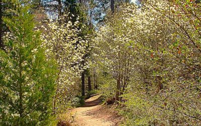
This popular trail, which is mostly sunny, winds its way through a number of ecosystems, including chaparral and riparian forest.
On the Trail
OK, let’s go hiking. From the lower parking area, the pathway heads up to the right past a sign with summary information. Briefly, I’ll note here that the trail was designed in 1993 by a group of carefully selected middle and high school students in consultation with Forest Service personnel and other professionals.
As you ascend, you’ll notice almost immediately a creek that’s usually bone dry this time of year. But, thanks to our extraordinary winter, the water music continues to delight passing hikers. Be ready to cross the creek ahead, stepping carefully on several well-placed stones.
Here you enter one of the trail’s steeper sections. The beaten earth briefly widens to between three and four feet, then narrows to a more typical two to three feet. Now, a few minutes into your hike, large boulders appear on either side of the pathway. They’re a portent of what lies ahead—namely, some of the most impressive granite boulder fields in all of these mountains.
Soon you come to the first major boulder array, crowned by the sun-bleached trunk of a tree that must have toppled at least a century ago. Around the corner you’ll notice how enormous the foundational boulder is. It’s a truly impressive geological feature.
As the trail becomes even rockier, it transitions into a series of switchbacks, then narrows and continues ascending. Loose gravel suggests the need for careful hiking. Also, mountain-bike tracks reveal that this is a popular trail for riders as well as hikers. It’s essential, then, to be vigilant—especially around blind curves—looking and listening for descending bikers. Some of them may signal their approach with warning bells.
Just shy of half a mile along, you’ll see an inviting bench to the right. Its prominent inscription reads, “In memory of Gary Brandenburg. DEDICATED TO THE CHILDREN.” Perfect!
Immediately beyond that memorial, the trail levels off for a while, descends briefly, then resumes a moderate upward course into an open area with fewer trees. Well beyond the pathway ahead, you can see heavily forested hillsides with rocky outcroppings.
Nearing the one-mile mark, you’ll come upon a Forest Service road. Don’t go left or right there. Instead, continue on the trail itself. As you ascend, you’ll notice a subtle forest phase change, as oak trees and their siblings cede the arboreal majority to conifers. You’ll notice, too, how well kept the pathway is—free of litter and with chaparral on both sides neatly brushed. Kudos to the Southern California Mountains Foundation, which manages the trail.
At about the 1.5-mile mark, the route really opens up, offering a panorama of nearly 270 degrees. Pause here to savor the buena vistas, including a striking view of the San Gabriel Mountains to the west.
Now the trail winds around and through more fortress-like boulder fields. Impressive, too, are the large Ponderosa pines, which are the dominant evergreens here. Near the two-mile mark on the left, one particularly stout specimen displays a blackened cavity rising nearly 10 feet from the ground. It’s a survivor of the 1970 Bear Fire.
Finally, when you encounter an especially massive outcropping of granite (after a steep section of trail), you’ll come to the 2.3-mile mark, which is slightly more than halfway. You can continue on, of course, if you have the time and energy. But for the purposes of this week’s column, we’ll declare this to be our turning-around point. How long have we been on the trail? Slightly more than one hour. Now we can traverse a mostly downward route, retracing our steps to the lower trailhead.
NOTES: While your hike will include shady stretches, this is a predominantly sunny trail. Especially in the summer, it’s essential to have protective headgear, sunscreen and plenty of water. Hiking in the morning or later in the day is recommended. Also, depending on your pace, allot two to three hours for the round trip. Be aware, too, that a Forest Service Adventure Pass (daily or annual) is required for parking.


0 Comments