

")
By TIM WILCOX – Special to the Alpine Mountaineer
Where: Running Springs/Arrowbear
Length: 4.6 miles (round trip)
Elevation gain: 750 feet (return trip)
Challenge: moderate
Last week we tackled the lower half of the Children’s Forest Exploration Trail. Now it’s time to hike the rest of this varied and scenic route.
Here’s how to get to the upper trailhead: From the main intersection in Running Springs, drive one mile east and downhill on Highway 18, past the elementary-school athletic field, to Keller Peak Road. Turn right there and wind four miles uphill. Turn right at the T-intersection and park in the turnoff where the weathered trailhead sign is located.
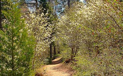
On the Trail
From this starting point, the pathway assumes its narrow format – typically between two and three feet wide. The initial section of the trail, where a strikingly stout Ponderosa pine presides, is mostly level. It also displays another key characteristic of the route: myriad twists and turns.
Soon enough, past another Ponderosa giant, the trail takes a definite downward turn. Several switchbacks lead to a large dry wash on the right. Last winter, during heavy rainstorms before repeated snowfalls, it must have been a roaring torrent.
Take care on the steeper segments where loose gravel is more prevalent than beaten earth. A slip could cause discomfort or worse. Be trail aware, too, with regard to the potential of rattlesnakes basking in the sun. They’re not a common sight but do appear from time to time.

In some spots the beaten-earth-and-gravel pathway surrenders almost completely to rocks and small boulders. Still, the trail remains negotiable from start to finish.
This is a mostly sunny route, which means that wearing head protection – a baseball cap or, better, a broad-brimmed trekking hat – is essential. The minority forested sections provide welcome shade. Here firs and pines predominate with a scattering of oaks and other deciduous trees.
One of the especially appealing features of the Exploration Trail’s upper half is that there’s almost no traffic noise. Busy Highway 18 is several miles away, and Keller Peak Road is lightly traveled. The only sonic intrusions from “civilization” are pesky passenger jets.
About three-quarters of a mile from the trailhead, you’ll cross over a smaller dry streambed. At this point, too, large boulder fields become more prominent. They’re a primary geological signature of this trail.
Nearing the one-mile point, you’ll come to an open area where a relatively new memorial bench invites a moment’s pause. Its inscription reads: “In Memory of Janiece Camacho. DEDICATED TO THE CHILDREN.” This vantage boasts the most panoramic view of the San Gabriel Mountains to the west. Later in the day, they usually appear as a hazy silhouette. Still, it’s an inspiring vista.
Now the trail becomes much wider for a short stretch, then returns to its more narrow format. Moments later you’ll need to clamor carefully over a collection of small boulders. The pathway’s twists and turns are amplified by subsequent granite outcroppings. Designing and then creating this trail must have been a monumental undertaking!
You may have noticed that, along with footprints on the trial, mountain-bike tire tracks are common. This is one of the most popular routes in our mountains for the two-wheeled sport. It’s important, then, to listen and watch for the approach of any bikers, especially when you’re hiking back uphill around blind curves.
If you have a pedometer, which is highly recommended, keep an eye on the tally. At about the 2.3-mile mark, you’ll have successfully traversed the trail’s upper half. Unless you feel inspired to proceed downhill, make this your turnaround point.
Because your return trek will be mostly uphill, it makes obvious sense to conserve energy on the downward hike, saving the balance of your metabolic fuel for the ascent. Also obvious but still worth repeating is that staying fully hydrated is crucial. Plan to carry more water than you think you might need. Finally, depending on your pace, allot two to three hours for this roundtrip adventure.
NOTES: As a reminder, the full trail is 4.5 miles one way with an elevation gain from the lower trailhead of about 1,500 feet. Unless you’re a seasoned and ultra-fit hiker, undertaking the nine-mile roundtrip is discouraged – especially in summertime. It’s much better to experience the Exploration Trail in two manageable increments, as we’ve done.


0 Comments