

")
By TIM WILCOX – Special to the Alpine Mountaineer
Where: Crestline
Length: 2.4 miles (round trip)
Elevation gain: 230 feet (return leg)
Challenge: easy to moderate
Heart Rock may be the most well-known trail in the western San Bernardino Mountains – particularly for visitors from down the hill. Why? Its proximity to Camp Seely is likely an important factor. This Los Angeles City facility has hosted countless schoolchildren, families and others for generations. Branching off from the camp’s grounds, the trail has always been a prime attraction of the site. Happy memories, then, must play a role.
Of course, it also draws many non-Seely hikers who’ve heard or read about the remarkable geological and hydrological formation at the trail’s lowest point. Word of mouth is a potent attractor.
Most hikers up here know how to get to the trail. But because access has become more complicated, we’ll rehearse it here (for hikers east of Crestline). Take Highway 18 to Lake Gregory Drive and turn right at the stoplight. Downhill a couple of miles, next to the lake, is Crestline’s main intersection. Turn left there at the stop sign and drive through town. When you start going uphill, watch for the old white church on the right.
Immediately beyond it and straight ahead is Knapps Cutoff (don’t continue going uphill). Follow the cutoff to a stop sign, which is the intersection with Highway 138. Continue forward and downhill, past a storage facility, then watch for a large open space on the left. That’s now the informal parking area for Heart Rock hikers.
In the past, you’d drive a little farther, turn left at the Camp Seely sign, then continue to the official trailhead parking lot. For whatever reasons, this convenient access has been blocked for some time now.
So, from the current parking area, walk toward Camp Seely, then down the road to the left that crosses the creek. A little farther on, take the wide pathway to the right through an open gate and onto a dirt road. That leads to the camp’s ancient swimming pool. Steps away is the trail’s entry point, which is about half a mile from where you parked.
On the Trail
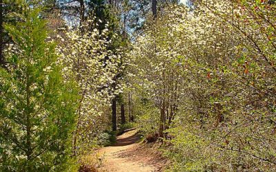
Initially and briefly, the pathway is wide and level. Then, narrowing slightly, it begins a steady descent. Immediately, you’ll notice something very unusual for the Heart Rock Trail in summer. Boulder-strewn Seely Creek, which is a major drainage channel for this area, is running with water. In recent years, it’s been mostly dry, with modest pools here and there. But thanks to our remarkably stormy winter, it’s alive with water music. Earlier, in spring, it was a roaring torrent.

Unusual for this time of year, a waterfall makes the famous heart-shaped formation (at left) even more impressive.
This is a rocky route with stretches of smooth beaten earth. Stones are embedded in the trail, and loose ones make it tricky in spots. Also, two or three times, the path narrows considerably with a steep drop-off to the right. Caution is the appropriate watchword – especially if young hikers are in your party.
Moving ever closer to Seely Creek, the trail narrows and then climbs into a stretch of rocks and boulders. When you encounter a wizened stump that looks like an arboreal throne, you’re almost there. A little farther on, you come to a steep and rocky downward slope that leads directly to the Heart Rock overlook. It’s the trail’s most treacherous stretch. Again, take special care with children!
Finally, about 1.2 miles from your starting point, you’ll encounter the namesake formation – a large hollow in the prominent granite outcropping that’s unmistakably heart-shaped. This remarkable feature has amazed and delighted hikers for decades.
How long did it take to form? I’m guessing many centuries. And because the creek continues to run, an 18-foot waterfall immediately to the right of Heart Rock provides the perfect natural complement.
Linger here for a while, savoring the sights and sounds. Then retrace your steps, fully aware that you’ve experienced a mountain treasure of the first order.
NOTES: Thanks to a healthy forest of deciduous and evergreen trees, the trail is shady much of the way. With daytime temperatures regularly in the 80s now, that’s a welcome situation. For obvious reasons, early in the morning and later in the day are the most comfortable times to hike.


0 Comments