

")

sims1

sims2
SIMS1:
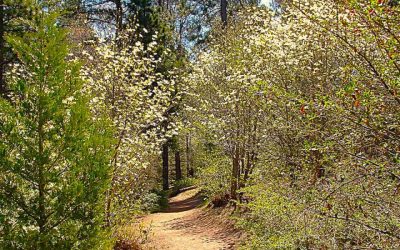
The Jim and Kathie Sims Trail is a study in contrasts. The initial segments are well maintained and neatly marked with logs and limbs. Elsewhere, though, the pathway becomes indistinct, potentially leading hikers off-trail. Here the route’s first major fork centers on a mid-trail arrowhead. (Photos by T. Wilcox)
SIMS2:
The trail opens up at its highest point, presenting a panorama dominated by Mt. San Bernardino, the third-highest peak in Southern California. From Highland and Redlands, this mountain has a strikingly different profile, looking like a stratovolcano.
LET’S GO HIKING
Jim and Kathie Sims Trail
By TIM WILCOX
Special to the Alpine Mountaineer
Where: Running Springs
Length: 3.2 miles (round trip)
Elevation gain: 980 feet
Challenge: moderate to semi-difficult
The Jim and Kathie Sims Trail is a hidden gem located less than a mile east of the main intersection in Running Springs. Traveling in that direction on Highway 18, go through the yield sign, then watch for Running Springs School Road. Turn right there and motor just past Charles Hoffman Elementary School. Finally, make a quick left into the Hootman Senior Center’s lot and park.
So, where’s the trailhead, anyway? It’s hidden as well. Walk up the parking lot’s slope and onto the school’s large baseball and soccer field. Across the expanse of grass, you’ll see two weathered shipping containers. That’s your next, but temporary, destination.
Immediately behind the containers and around a fence to the left is the elusive trailhead. Confirming that you’re headed in the right direction, a barely legible sign displays the all-caps tagline, “TURNING KIDS ON TO WILD PLACES.” This is definitely a popular and much-loved trail for mountain schoolchildren.
On the Trail
The path ascends steeply for the first half mile, winding uphill through numerous switchbacks and imposing boulders. One of them is as big as a house. I’d estimate that it’s about 40 feet long and nearly 20 feet tall. Wow!
Steps beyond that behemoth is a short spur to the right. There, atop another boulder, you can look down on the athletic field and see how far you’ve climbed in just a few minutes. From this vantage, too, the tip of Strawberry Peak appears and, much farther to the west, the San Gabriel Mountains. Past the spur, the path finally levels out for a stretch before ascending once again.
You’ll be impressed by how carefully the trail has been laid out, winding through the boulders. Also, the margins of the trail – along some of the way, at least – are neatly delineated by carefully placed logs and limbs.
Just beyond the half-mile point, the trail continues its level march forward. Soon you reach a triangular “construct” that seems to be more decorative than functional. Maybe it’s meant to be an arrowhead. Whatever the case, you’ve come to a major fork in the trail. To the left the pathway remains narrow with many uphill contortions. To the right it widens considerably, heading downhill for an extended stretch. Go that way.
When you come to what looks like a Forest Service road, don’t turn right. Why? Because a quarter mile later, you’ll end up on Running Springs School Road.
Instead, head left up the rocky road for half a mile. Then, when you encounter another fork, hike uphill to the right on the still-wide pathway. Be aware that it’s easy to meander off course on what looks like the trail but actually leads to a dead end. You may have to retrace your steps and try a different route. There’s no signage here whatsoever.
If you’re successful, you’ll come to the trail’s principal view point, marked by two wooden lawn chairs. To the east is an absolutely magnificent view of Mt. San Bernardino, a massive peak 10,649 feet high. Looming behind it is San Gorgonio, Southern California’s tallest mountain at 11,503 feet. In the near distance is Keller Peak, just shy of 8,000 feet. This spot is special not only because of the view, but also because it’s so quiet.
Heading down from its buena vista pinnacle, the trail widens and soon brings you back to the rustic road. Hike to the right for a ways and watch very carefully for four small boulders in a row by a fir tree. Don’t miss this juncture! Turn left and, amazingly, you’re back on the trail. When you come to another T-intersection, go left past a large Ponderosa and another huge boulder field.
When you encounter yet another fork, head down to the right rather than up to the left. For quite a stretch at this point, you’ll descend through a steep and winding route littered with loose rocks. Walk carefully, please!
Finally, you’re back at the arrowhead configuration. Breathe a sigh of relief. You’re not lost after all! Now you simply need to retrace your initial steps. Some 20 minutes later, you’re back on the ball field.
NOTES: This is challenging trail for two reasons. First, the elevation gain is nearly 1,000 feet over the course of slightly less than two miles. Second, the upper pathway is indistinct in spots with no helpful signage, including simple arrows that could keep hikers from wandering off-trail. Be prepared for cul-de-sacs and sudden “route adjustments.” That said, the clear rewards are splendid boulders and wonderful views from several vantage points.


0 Comments