

")
By TIM WILCOX
Special to the Alpine Mountaineer
Where: Lake Arrowhead
Length: 2.2-mile round trip
Elevation gain: 122 feet
Challenge: easy to moderate
Please file this route under “a trail less taken.” Another hidden gem, it’s situated immediately west of Lake Arrowhead Country Club, above Brentwood Drive. There are several ways to get here, and driving directions may sound complicated. But with simplicity and efficiency in mind, let’s establish a prominent starting point: the Shell gas station in Agua Fria at the intersection of Grass Valley Road and Highway 189.
Take Grass Valley north about one-half mile to Clubhouse Drive. Turn left and follow Clubhouse for about one-tenth of a mile to Fairway Drive. Turn right on Fairway and proceed for about one-half mile to Brentwood Drive. Follow Brentwood for slightly less than a mile to Sonoma Drive (street sign on your right) and turn left. Approximately one-tenth of a mile on the left is Forest Service Road 2N34—directly across from Sutter Street. There’s parking for one or two vehicles at the bottom of the Forest Service road. You also can park off the pavement on Sonoma or Sutter.
On the Trail
OK, you’ve arrived—or almost, at least. You’ll need to walk up the wide dirt road for about half a mile before actually reaching the trailhead. This access route is the steepest part of your overall hike, though it’s quite manageable. You’ll encounter some forks along the way, so be sure to keep to your right.
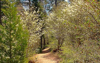
A few steps from the last fork, just past a large oak whose trunk and two main limbs form a Y, is the trailhead, marked by a small sign and two entry posts. You’ll discover that, initially, it’s a narrow path through stands of Manzanita and other hardy shrubs.

The makeshift bench at trail’s end—a heavy wooden beam resting on large rocks—promises and delivers magnificent views of canyons, passes and mountains to the west.
The trail continues its narrow aspect, passing through lightly forested areas of pines with a meager supporting cast of oaks. Off to the right you’ll catch a glimpse of mountains to the east and, steps farther along the gently rising route, views of the high desert to the north. Because you’re ambling along Arrowhead Ridge, you’re treated to vistas in several directions.
Approximately eight-tenths of a mile from the starting line, you’ll encounter an open space offering splendid views of the San Gabriel Mountains to the west and the eastern “finger” of Silverwood Lake far below in the valley. Later in the day this vista is often hazy, creating a Japanese-watercolor effect. Clear views tend to be the privilege of morning and early-afternoon hikers.
In the past you could continue on a track to the left that narrows to about one foot. It led to a steep and rocky pathway through the chaparral. Now, however, the hardy native shrubs have completely overgrown the route. Bushwhacking through the spiky vegetation is definitely not recommended. It’s likely to put a tactile damper on your hike. Even more, this section of the ridge has a number of hidden drop-offs to the canyon far below, which could cause a sudden, dramatic and unwelcome loss of altitude.
It’s much better and wiser, then, to take the Forest Road to your right and hike for another two-tenths of a mile or so. When you come to a large loop on the left, look for two more posts and another trailhead sign. You’re almost there. Pass through the posts and follow the narrow pathway to the right and uphill for another tenth of a mile. There you’ll discover a heavy wooden beam placed atop small boulders. Wordlessly, yet compellingly, it invites hikers to have a seat and savor one of the premier views from the western San Bernardino Mountains.
Now you can retrace your steps along the Forest Service road and more scenic portions of this hidden gem. Your return trip is inevitable, but it shouldn’t be rushed.
NOTES: This is not an easy trail to find, but it’s definitely a good one to hike. From our neighborhood of the San Bernardino Mountains, it offers some of the most-unimpeded and striking San Gabriel Mountain vistas. Because it’s situated on a ridgeline, the trail also presents views of mountains to the east. The route’s name probably has something to do with the prominent, light-blue outlet tower near the northeastern boundary of Lake Arrowhead. That historic connection isn’t immediately clear.


0 Comments