

")
By TIM WILCOX
Special to the Alpine Mountaineer
Where: Lake Arrowhead
Length: 2.6-mile round trip
Elevation gain: 772 feet (return leg)
Difficulty: easy (descent), semi-difficult (ascent)
The official name of this route is the North Shore National Recreation Trail. That’s a bit much, frankly. Many local hikers simply call it the North Shore Trail.
It begins at the eastern end of the North Shore Campground, situated above Mountains Community Hospital. While the trailhead is clearly marked by a large Forest Service sign, it’s not easily accessible. There are no day-use parking spots in the campground. Now, in late-October, it’s closed for the season. Your best bet, then, is to leave your vehicle in the large public lot at MacKay Park.
If that’s your starting point, you don’t have to walk up into the campground (still accessible by foot), whose entryway is next to the hospital’s parking lot. Instead, from MacKay Park go east along Hospital Road to the point where it makes a sharp turn and heads downhill. You’ll see a dirt road to the left (Rouse Ranch) that runs by the construction site of the Lake Arrowhead Community Services District’s new maintenance headquarters. Walk through an open swing-out gate and down the hill about 140 paces. Watch carefully on the left for a pathway descending from the campground and, a few steps farther, the continuation of that route. Head right there, and you’re on the North Shore Trail.
On the Trail
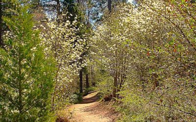
The pathway, quite wide at this juncture, leads to a more narrow route, which is standard for the trail. If you look around as you wind down the hill, you’ll be struck by how dominant oaks are in this area. Pines and firs are absent.

Several stretches of the route are dominated by robust stands of chaparral on either side, with small oaks scattered among the hardy shrubs.
The trail is quite rocky in spots, covered with loose stones, so proceed with care. The vegetation on either side consists of the evergreen Manzanita and other shrubs common to our chaparral biome. This is definitely not an alpine forest trail.
The path traces the descent of Little Bear Creek – mostly dry this time of year. Like the creek, the trail meanders considerably, which makes it interesting. So do views of rocky hillsides to the left and, farther down the route, more distant vistas of the ridgeline above Green Valley Lake to the east.
After hiking for half a mile or so, you’ll have noticed that you’re heading downward with few level spots and none that ascend. Of course, this means that your return journey will be a mostly “on the rise” experience. Conserve your energy and just “glide” down the hill with minimal effort.
A big hairpin turn in the trail marks what could be the midpoint of its descending segment. Yet another sharp turn leads you onto a particularly rocky section, where caution is advised again.
Soon you come upon a stretch littered with downed trees, many of them in the dry creek bed itself. Those arboreal remnants are souvenirs of powerful torrents in the past.
Just beyond the one-mile mark, you cross the creek itself, head uphill gently and then continue down the trail once again to an open space and T-intersection.
At this point, about 1.3 miles in, you have to make a decision. While you’re still about four-tenths of mile from trail’s end (near Splinter’s Cabin), this leftward portion is overgrown. Even more important, its initial stretch is covered in standing water, thanks to our dramatic, most-recent winter. It’s probably wise, then, to declare this your turnaround point and head back up to the informal trailhead.
You’ll also see a pathway branching off from the trail to the right next to a large downed tree. This is an alternative return route whose initial trail across dry stream beds leads to Big Tree Road past an impressive manor house to Little Bear Creek Road. Turn right at the white fence, then walk for a ways along the dirt road until you come to pavement.
Now you’re on Torrey Road, which presents a nearly half-mile trek uphill past the Papoose Lake dam. When Torrey levels out, you’ll soon come to a stop sign. Turn right there and head up Rouse Ranch Road, around the hairpin turn to the left and on to MacKay Park.
If you decide to retrace your original route at the T-intersection, hiking energetically uphill, you’ll cover about 2.6 miles. If you opt for the alternate route, it’s 2.8 miles.
NOTES: This is a sunny, mostly narrow trail that offers an easy descent through copious chaparral and a more challenging ascent on your return trip. Because of the vegetation and terrain, it feels more like a high-desert hike than a mountain-trail outing.


0 Comments